
New instructions for using TOPO! with Magellan Triton is now live at topo-triton.com along with details on how to contact us for support.
I hope you find a Triton + TOPO! under your tree!
December 21, 2007
New Triton Tech Info is Live
Filed under:
gifts,
GPS,
National Geographic maps,
TOPO,
topographic maps,
Triton
![]()
Sphere It!
![]()
![]()
![]()
![]()
![]()
December 20, 2007
Idiot Proof?
A member of our sales team called today and I mentioned I was in the midst of testing updated instructions on transferring TOPO! maps to Triton, having unboxed a 1500 unit.
He asked, "So you want to see if it's idiot proof?" I didn't take umbrage. He knows I'm not exactly a GPS power user.
The good news is the directions worked easily. We're just fine tuning them and some additional tips and will have them on the web in a day.
Since this was my first time handling a Triton I'll say I liked the feel of it, loved the screen, especially the touchscreen operation. And the TOPO! maps I transferred looked great.
Meanwhile, Magellan informs us that the flood gates have opened and many more Tritons will soon be washing into stores near you.
Filed under:
GPS,
Magellan,
National Geographic maps,
TOPO,
topographic maps,
Triton
![]()
Sphere It!
![]()
![]()
![]()
![]()
![]()
December 12, 2007
Question about Magellan Triton Delays
A Contours reader writes:
What is your view on the matter of the non-availability of a GPS-device (Magellan Triton) which is praised on your own web-page?
While we are not happy that the release has been delayed, more models are shipping to more stores each week. This is a new line that will be a standard for some years and so we view the delay as a short term disappointment.
While our relationship with Magellan is not exclusive, we are working closely with them and promoting the Triton line because they are the first company to do what thousands of our users and dealers have been asking GPS manufacturers to do for years: Allow them to transfer TOPO! maps to their handhelds.
Filed under:
GPS,
Magellan,
National Geographic maps,
TOPO,
topographic maps,
Triton
![]()
Sphere It!
![]()
![]()
![]()
![]()
![]()
December 3, 2007
Where to buy Triton GPS
Last month we let you know the exciting news about a new line of GPS handhelds that will be the first to support tranfer of TOPO! maps to view and track on-screen.
Magellan's Triton units have begun shipping. A report on where to find them appears here today.
Filed under:
GPS,
Magellan,
map software,
topographic maps,
Triton
![]()
Sphere It!
![]()
![]()
![]()
![]()
![]()
Maps Lead to Adventure
That headline is a motto we've used for some time. But right now it's literally true.
Now through December 31st, purchase one of our outdoor recreation map software products and qualify for a one-year subscription to Adventure Magazine.

Participating dealers will have tear-off coupons for submitting your claim. Online retailers will have a PDF redemption form. You can also find it here.
The offer applies to the TOPO! State Series, Weekend Explorer 3D, Back Roads Explorer 3D, National Parks Explorer 3D and our other outdoor map software products.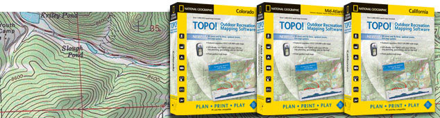
Where to buy:
Retail
Your local independent outdoor specialty shop.
Online
National Geographic Online Store
REI.com
GeoMart
Swiftmaps
Digital Map Store
Offroute.com
The GPS Store
GPS Now
Map Outfitter
Software-Maps.com
Amazon.com
Filed under:
gifts,
map software,
National Geographic maps,
recreation maps
![]()
Sphere It!
![]()
![]()
![]()
![]()
![]()
December 1, 2007
Concise Atlas of the World, Second Edition
National Geographic Books has just released the National Geographic Concise Atlas of the World, Second Edition, a condensed yet complete world portrait.
This edition includes more than 3,000 updates, 32 new pages of expanded content, and 500 maps, charts, graphs, flags and illustrations. All the maps are fresh, newly researched and state-of-the-art, reflecting the latest changes in the world. Topics covered are informative, relevant and interesting, providing readers with the most current geographic knowledge and global trends. 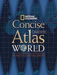

Smart navigational features and intuitive design elements make reference searches easy and quick.The atlas opens with beautifully rendered, up-to-date, thoroughly indexed, political and physical maps of the world. World thematic maps follow, presenting plate tectonics, climate and weather, oceans, population, religion, energy and the economy. Health and education, environmental stress, and conflict and terror are also covered, providing a review of the increasingly complex issues we face today.
A newly compiled time zone map is added, as well as a special section on the United States, providing more in-depth coverage, including population changes, most prevalent religious groups, risk to property from natural disasters, and national parks and reserves. The full-color physical and land cover maps enhance and enrich readers' understanding of Earth's natural features.
New continental maps cover water availability, dominant economies, energy consumption, population density, climate and natural events such as earthquakes, volcanoes and tsunamis. Country profiles provide valuable and useful facts for all 193 independent nations of the world. Never-before-published satellite mosaics depict the Earth in high resolution from hundreds of miles above.
It's a fantastic value at $24.95.
160 pages
350 color maps, graphics, satellite images, and photos
10 1/4 x 13 1/2
Softcover
10 1/4 x 13 1/2
Softcover
ISBN: 978-1-4262-0196-7
Filed under:
National Geographic maps,
world atlases
![]()
Sphere It!
![]()
![]()
![]()
![]()
![]()
November 30, 2007
Framed and Mounted Maps
A framed or mounted wall map can make a great gift. There are several retailers who offer our maps enhanced in this fashion.
The National Geographic Online Store has a nice selection of framed NG maps.
Maps.com, 4 Corners Maps, McMaps.com, Omnimap and SwiftMaps offer mounted NG maps as described below:
Art.com has a number of framing and mounting options for NG maps.
And if you are in the vicinity of a Sportsman's Warehouse store, they stock our Classic World, Executive World and Executive USA mounted maps.
Filed under:
gifts,
National Geographic maps,
reference and wall maps
![]()
Sphere It!
![]()
![]()
![]()
![]()
![]()
November 27, 2007
Triton GPS Units are shipping
The long-awaited Triton line of handheld GPS units from Magellan have begun shipping. Not all models are in stores yet but we know some have arrived as we've heard from people who have bought them and are beginning to upload our TOPO! maps to their units.
Check out topo-triton.com for more details, links to a how-to and free upgrade for Triton users.

Watch a video about the top-of-the-line (not in stores quite yet) Triton 2000.
Filed under:
GPS,
Magellan,
National Geographic maps,
TOPO,
topographic maps,
Triton
![]()
Sphere It!
![]()
![]()
![]()
![]()
![]()
November 23, 2007
Looking for a map-related gift?
 If you're a member of Costco, Sam's Club or BJ's Wholesale, look for the National Geographic Deluxe Map Collection.
It's a boxed set of 30 reference maps, including the world, continents, and selected countries, regions, space and thematic titles.
Filed under:
gifts,
National Geographic maps,
reference and wall maps
![]()
Sphere It!
![]()
![]()
![]()
![]()
![]()
Onion Made Us Cry
A column by Al Lewis about the satirical newspaper The Onion in today's Denver Post mentions their new atlas, Our Dumb World.
Says Onion CEO Stephen Hannah, "Our atlas is doing better than anything Rand McNally or National Geographic has done in a while. They are not on the bestseller lists."
We realize it's The Onions role to tweak, but the truth must out:
For the record, book bestseller lists do not take account of the many thousands of National Geographic world atlases purchased by our members through the mail. And if they included all the Wal-Marts and gas stations that sell road atlases, Rand McNally's would be perennially on the top of the list as they move millions every year.
Among the Onion's many subjects of ridicule in their atlas: our famous Afghan girl. Well, we're really not crying, but permit us to sniff!
Filed under:
Rand McNally,
The Onion,
world atlases
![]()
Sphere It!
![]()
![]()
![]()
![]()
![]()
From the Glove Compartment to the Shelf
"If 90 percent of life is showing up, the other 10 percent is figuring out how to get there. That’s where maps come in."That's the lead on a round-up of recent books about maps in today's New York Times.
Filed under:
books about maps
![]()
Sphere It!
![]()
![]()
![]()
![]()
![]()
November 22, 2007
Not Just Another Map Exhibit
A swift kick from the Chief Cartographer reminds me to let you know that if you can get to Chicago, the Museum of Science & Industry is hosting National Geographic's Maps: Tools for Adventure through January 6th. It was developed in cooperation with the Children's Museum of Indianapolis.
Along with the Field Museum exhibit, it's part of Chicago's Festival of Maps.
Filed under:
Chicago,
Festival of Maps,
geography education,
National Geographic maps
![]()
Sphere It!
![]()
![]()
![]()
![]()
![]()
Virtual Map Exhibition

Can't get to Chicago to visit the Field Museum's exhibit Maps: Finding Our Place in the World?
Visit the fantastic exhibit web site, especially two interactives: Explore Maps of the World and a virtual walk-through of the gallery.
Filed under:
Chicago,
geography education,
map history,
old maps
![]()
Sphere It!
![]()
![]()
![]()
![]()
![]()
November 18, 2007
Arizona-Sonora Desert Region MapGuide

 NGMaps has produced a series of Geotourism MapGuides in association with the NGS Center for Sustainable Destinations.
The Arizona-Sonora map is available from the State of Arizona web site as a PDF, interactive map, and while supplies last, a printed version.
The map highlights the natural, historic, and cultural features unique to this region.
Filed under:
Arizona,
geotourism,
National Geographic maps,
Sonora
![]()
Sphere It!
![]()
![]()
![]()
![]()
![]()
November 8, 2007
NGS Sponsors New Mountaineering Museum
 National Geographic is a sponsor of the Bradford Washburn American Mountaineering Museum, which will open in Golden, Colorado next February.
Through historical artifacts, visual and tactile experiences, and multimedia exhibits, the museum will inspire and educate the visitor about mountaineering, how and why mountaineers climb, and the mountains themselves. Portions of the exhibit will be devoted to international themes such as mountain cultures and sacred mountains, regional themes like Colorado's climbing history and the 10th Mountain Division, and global concepts like conservation and safety in mountain environments. The museum will also serve to honor the accomplishments of both its namesake, Bradford Washburn, and the many American mountaineers who followed in his pioneering footsteps.
Brad Washburn was not only a mountaineer and explorer, but a great cartographer. Washburn was project director for our topographic map of Mt. Everest (pictured below) and announced the revised elevation of Everest measured by an expedition co-sponsored by the Society in 1999.

The museum's gift shop will open November 23rd, so if you're in the Denver area consider stopping by. You'll find some of our map products for sale there.
Washburn was perhaps best known for his exploration of Alaska:
Our Newest World Map - Back to the Future
 World Hemispheres
 National Geographic’s new World Hemispheres map draws its inspiration from some of the classic National Geographic world maps of the 1930s and 1940s.
While most modern world maps show the world as a whole, the hemispheres map was designed by NG Maps using a projection that separates the Eastern and Western hemispheres.
This unique projection shows continents and regions in truer proportion to each other than most other map projections are able to achieve. The map features updated, modern cartography and an elegant earth-tone color palette.

December 1935
NG Maps produced its first hemisphere world map for the December 1935 NGM. The map was created under the tutelage of chief cartographer James Darley and designed by Charles E. Riddiford. It featured insets that showed views of the Earth’s “Land Hemisphere” and its “Water Hemisphere” as well as insets showing the world’s time zones. It also listed some facts about the Earth, including its polar and equatorial diameters; its total area (196,950,284 square miles); the mass of the atmosphere, water, ice, lithosphere; and the total mass of the Earth.
December 1941
The 1935 map was followed by an updated version in December 1941. Albert H. Bumstead was the chief cartographer for this gem, with a “Culture” inset by James Darley and a “Physiography” inset by Charles E. Riddiford. The 1941 map had a decidedly brighter palette than its predecessor, and featured several insets, perhaps the most interesting of which was a star-shaped projection that showed the relative accuracy of the mapping information by region.

April 1943
In April 1943, a world map was published, though instead of featuring the Eastern and Western hemispheres, it showed the Northern and Southern hemispheres. James Darley was chief cartographer, and Charles E. Riddiford designed the map. This fascinating worldview highlights the land mass of the Northern Hemisphere and the relatively close proximity of North America to the USSR and northern Europe. For the first time on an NG world map, air distances were shown between cites across the globe.
Look for the new World Hemispheres map at your favorite map store or online map retailer.
Look for the new World Hemispheres map at your favorite map store or online map retailer.
November 7, 2007
New Trails Illustrated Title: New River Blueway

National Geographic Maps is pleased to announce our newest Trails Illustrated title, but with a twist.
This title has a "Geotourism Feature" that not only highlights recreational amenities, but also the region's cultural and physical features of select areas of North Carolina, Virginia and West Virginia, with a focus on the New River, an EPA designated American Heritage River.
Whether you're planning a float trip or visiting the many protected parks and natural areas, this map can serve as an excellent trip-planning tool and cultural resource.
Stanford's of London
Want to see the biggest map store in the world?
Visit London, and steps from Covent Garden you'll find Stanford's.
 They celebrated their 150th anniversary in 2003 with a total refit of the main store (they also have a location in Bristol and an excellent online store).
One of the unique features of the main store is that the floor tiles comprise enlarged images of maps.
The lower floor has an XYZ street map of London, the top floor has our map of Everest, the ceiling has our Milky Way map, and the main floor features our Classic World Map, pictured below.
Stanford's is simply a map-lover's paradise!
Filed under:
cool map stuff,
map stores,
National Geographic maps
![]()
Sphere It!
![]()
![]()
![]()
![]()
![]()
Our newest world map: Back to the Future
World HemispheresNational Geographic’s new World Hemispheres map draws its inspiration from some of the classic National Geographic world maps of the 1930s and 1940s.While most modern world maps show the world as a whole, the hemispheres map was designed by NG Maps using a projection that separates the Eastern and Western hemispheres.
This unique projection shows continents and regions in truer proportion to each other than most other map projections are able to achieve. The map features updated, modern cartography and an elegant earth-tone color palette.
December 1935
NG Maps produced its first hemisphere world map for the December 1935 NGM. The map was created under the tutelage of chief cartographer James Darley and designed by Charles E. Riddiford. It featured insets that showed views of the Earth’s “Land Hemisphere” and its “Water Hemisphere” as well as insets showing the world’s time zones. It also listed some facts about the Earth, including its polar and equatorial diameters; its total area (196,950,284 square miles); the mass of the atmosphere, water, ice, lithosphere; and the total mass of the Earth.December 1941
The 1935 map was followed by an updated version in December 1941. Albert H. Bumstead was the chief cartographer for this gem, with a “Culture” inset by James Darley and a “Physiography” inset by Charles E. Riddiford. The 1941 map had a decidedly brighter palette than its predecessor, and featured several insets, perhaps the most interesting of which was a star-shaped projection that showed the relative accuracy of the mapping information by region.
April 1943
In April 1943, a world map was published, though instead of featuring the Eastern and Western hemispheres, it showed the Northern and Southern hemispheres. James Darley was chief cartographer, and Charles E. Riddiford designed the map. This fascinating worldview highlights the land mass of the Northern Hemisphere and the relatively close proximity of North America to the USSR and northern Europe. For the first time on an NG world map, air distances were shown between cites across the globe.
Look for the new World Hemispheres map at your favorite map store or online map retailer.
Look for the new World Hemispheres map at your favorite map store or online map retailer.
Filed under:
National Geographic maps,
old maps,
world maps
![]()
Sphere It!
![]()
![]()
![]()
![]()
![]()
November 5, 2007
Cartograms Depict Worldwide Mortality

In a collaborative effort spearheaded by researchers at the University of Sheffield in England and the University of Michigan, WorldMapper released over 100 cartograms that graphically depict population growth, land mass, trade, worldwide mortality and more.
The worldwide mortality and world population cartograms at the top show the disparaging difference between the population of certain countries and morality from often curable diseases.(note Africa). The maps use 2002 data from the World Health Organization's (WHO) Global Burden of Disease project to put a geographic twist on cause-of-death statistics.
Of the roughly 57 million people who died in 2002, more than 18 million succumbed to communicable diseases, complications from childbirth, or nutritional deficiencies, according to WHO. Worldmapper labels these deaths as "often preventable" because the conditions could have been easily treated with modern medicine.
Learn more on National Geographic's website by following this link: "Death Maps" Pinpoint Mortality Cases.
Filed under:
cartograms,
World Health Organization,
WorldMapper
![]()
Sphere It!
![]()
![]()
![]()
![]()
![]()
November 3, 2007
Map Exhibits

News of map exhibitions coming to Chicago and Washington in USA Today.
Filed under:
geography education,
map history,
old maps
![]()
Sphere It!
![]()
![]()
![]()
![]()
![]()
November 2, 2007
Dominican Republic adventures
 The Dominican Republic is a popular resort destination, but its reputation for outdoor recreation is rapidly growing.
A variety of adventure sports opportunities are available, including hiking, rock climbing, mountain biking, river rafting, four-wheeling, diving, surfing and paragliding.
And now, we present the map that will guide you to your Dominican adventure.


The new Dominican Republic Adventure Map is hot off the presses and will be coming to a map, book or outdoor store near you in the coming weeks.
Real TOPO Maps on a GPS


Our friends at Magellan are introducing an exciting new line of handheld GPS receivers called Triton that will be hitting stores in the next few weeks.
We're particularly thrilled about this line because it will be the first GPS line offering users the ability to view authentic USGS topographic maps using our TOPO!® software.
Until now, topographic maps available for use on GPS units from major manufacturers have been simplified vector maps that do not have the richness of detail and image quality offered by our enhanced scans of USGS quads.
Watch this page for more information. We'll soon post a free TOPO! upgrade to enable use with Triton.
Filed under:
GPS,
Magellan,
National Geographic maps,
TOPO,
topographic maps,
Triton
![]()
Sphere It!
![]()
![]()
![]()
![]()
![]()
November 1, 2007
GIS Day - November 14
GIS Day provides an international forum for users of geographic information systems (GIS) technology to demonstrate real-world applications that are making a difference in our society. More than 80 countries will participate in holding local events such as corporate open houses, hands-on workshops, community expos, school assemblies, and more.
If you haven't heard of GIS, according to the National Center of Geographic Information and Analysis:
a GIS is a system of hardware, software and procedures to facilitate the management, manipulation, analysis, modelling, representation and display of georeferenced data to solve complex problems regarding planning and management of resources
GIS is a part of our lives, whether we realize it or not. When you go to a retailer's web site and search for store locations by zip code, you're using GIS. When the Centers for Disease Control collect information on occurences of a disease, it is georeferenced data that can be analyzed as well as visualized on a map.
The National Geographic Society is a principal sponsor of GIS Day. Visit the GIS Day web site for more information.
Filed under:
geography education,
GIS
![]()
Sphere It!
![]()
![]()
![]()
![]()
![]()
October 31, 2007
nüvi Movie
Interesting clip from the NatGeo Channel's "Road Trip Tips" about in-car navigation:
The folks at Garmin seemed pleased.
Filed under:
Garmin,
GPS
![]()
Sphere It!
![]()
![]()
![]()
![]()
![]()
NatGeo Magazine Interactive Maps
There's a section of the National Geographic Magazine web site that offers interactive features, including some great maps.
Click around the maps to bring up photos and other content related to that place.
Here are links to a few:
Here are links to a few:

A snippet of what I saw when I clicked on "Lahore"
Filed under:
cool map stuff,
National Geographic maps,
online maps
![]()
Sphere It!
![]()
![]()
![]()
![]()
![]()
October 30, 2007
Oh, The Places You've Been
Here's a very cool widget:
TravBuddy.com lets you check off the countries (and US states, Canadian Provinces) you've been and then returns a map of your travels to you with a web link as well as code for posting on your blog or web page. Get it here.
This is a section of my world travel map. Green shows where I've been in the US:
Filed under:
cool map stuff,
online maps
![]()
Sphere It!
![]()
![]()
![]()
![]()
![]()
October 29, 2007
Map Help for the Classroom
 Xpeditions is a National Geographic resource for geography educators.
Included is an Atlas offering hundreds of free printable black & white maps such as these:

Filed under:
cool map stuff,
geography education,
National Geographic maps,
online maps
![]()
Sphere It!
![]()
![]()
![]()
![]()
![]()
October 28, 2007
Unfolding Map Supplements
If you get a new issue of National Geographic Magazine that includes a supplement map and wish you could have an unfolded copy, we have in the past year started saving a limited number of maps before they hit the folding machine.
While available, they can be purchased by calling our Evergreen, Colorado office at 800-962-1643.
Filed under:
National Geographic maps,
reference and wall maps
![]()
Sphere It!
![]()
![]()
![]()
![]()
![]()
October 27, 2007
Dr. Evil Didn't Have a Clue
How much is a map company worth?
The map industry has been shaken (or at least stirred) in recent months by announcement of two acquisitions totaling more than ten billion dollars!
In July, GPS maker TomTom announced an agreement to acquire Tele Atlas. Six weeks later, phone maker Nokia said it will buy NavTeq. Together, Tele Atlas and NavTeq supply most of the data for most in-car navigation systems, map web sites and software, as well as many publishers of street and road maps around the world.
Neither company publishes maps. Their business model is providing data to those that do publish, whether in electronic or print form. Through enormous investment that in past years has been considered risky by some, these companies turned the map industry on its head and may have turned some companies into the equivalent of the buggy whip manufacturers of the last century.
It's a classic business tale of the company that thinks they're in the whip business, when in fact they were in the transportation accessory business. Thus, when the new form of transport didn't require a whip, they went under.
Traditionally, map companies have collected map data, then published it, and then distributed it. In today's world it is possible to separate these three functions among two to three companies to achieve the end result. The business models are evolving and nobody, including the two companies that have pledged $10,000,000,000+, really knows how it will all shake out. But the bet is that services and information, rather than hardware, are where the largest profits will be.
The good news for consumers is that more maps can be accessed in more forms and places than ever before. The old-fashioned street map and road atlas are still with us. But you can also use a GPS to tell you how to get someplace without ever viewing a graphical map display.
As to National Geographic Maps, we continue to have a successful and growing business in the publication of printed wall maps and outdoor recreation maps. We have already been in the business of map software for some years. All of our maps are now generated from digital data. This puts us in a good position to take advantage of emerging technologies and the opportunities they present.
But even as we make more of our mapping available in digital media, we also believe that, at least for the kinds of maps we create, the printed form is a great user interface.
Update Oct. 31, 2007 >
GPS maker Garmin outbids TomTom for TeleAtlas
Filed under:
GPS,
map industry news
![]()
Sphere It!
![]()
![]()
![]()
![]()
![]()
October 26, 2007
Panama Then & Now
Early in the history of map supplements at National Geographic, in February of 1912 we produced a Bird's Eye View of the Panama Canal, which was then nearing completion. Last fall, in cooperation with the Panamanian government, we published an AdventureMap of Panama. This two-sided waterproof, tearproof map shows all of Panama at a scale of 1:475,000 (8 miles to the inch) and includes detailed insets of Panama City and the Canal Region (excerpt below). Map notes, text blocks and photos make this map into a mini-guidebook, making it a great planning tool for an outdoor recreation trip to Panama and to use in-country as well.

Filed under:
Adventure Maps,
National Geographic maps,
old maps,
Panama,
topographic maps
![]()
Sphere It!
![]()
![]()
![]()
![]()
![]()
Old National Geographic Maps
We often are asked for maps that appeared as supplements to National Geographic Magazine in years past.
Although a few are in our current catalog, most are out of print. Of course, you might get lucky find what you want at a flea market or on eBay. But even if in excellent shape, it will be folded.
Now there is a way to view nearly all of our old supplements, and, if desired, buy a ready-to-frame copy printed on demand. Check out the National Geographic Maps Classic Collection offered by our partner maps.com. 
Right now the collection goes up to 1999 and we are working on adding more recent maps.
A related question we are often asked is how to obtain a back issue of the magazine. That information is here. If the issue you want included a supplement, the map will still come with that magazine.
Filed under:
National Geographic maps,
old maps,
reference and wall maps
![]()
Sphere It!
![]()
![]()
![]()
![]()
![]()
October 25, 2007
About This Blog
This is the official blog of National Geographic Maps. We are a division of the National Geographic Society with offices in Washington, DC and Evergreen, Colorado USA.
We publish reference maps, outdoor recreation maps and mapping software, and professional mapping applications. We produce maps for other divisions of NGS such as magazines, books, videos and the web.
Through this blog we’ll update you on our activities and what’s going on in the world of mapping, and answer some of your questions.
Filed under:
about
![]()
Sphere It!
![]()
![]()
![]()
![]()
![]()
Subscribe to:
Posts (Atom)


